Major Projects
v National Base Mapping
 |
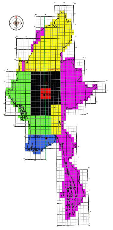
Myanmar UTM Pilot Project (2000-2001, 11700 sq-km) • Myanmar Datum 2000 (Establishment of Aerial Photography (1 : 25000) Myanmar UTM Phase (2) Project (2001-2002, 120000 sq-km) • Establishment of Aerial Photography (1:50000)
|
v JICA Comprehensive GIS Database Project (2002-2004, 27000 sq-km)
• Aerial Photography (1:50000)
• Ground Control Pointing
• GPS Survey by Differential Global System
• Positioning System
v Nam San-Monei-Linkhay National Highway rehabilitation development project
The project includes Field Survey and Detailed Designing of Road Alignment for the 81 km of the National Highway system linked to Eastern Shan State of Mong Pan – Ta Sang – Mong Ton was developed by the Shwe Thanlwin Highway Co. Ltd. under the BOT agreement from the Ministry of Construction. Road alignment which complies with AASHTO standard and bill of quantities for construction work has been delivered.
v Kyaw-Myatmyaung Railway preliminary and detailed engineering design project
The project's objective was to connect the missing link of Pakukku – Kyaw railway line and Myatmyaung – Gangaw railway line in northwestern Myanmar . The preliminary alignment was designed from aerial photogrammetric maps and detailed design was done based on detailed topographic survey of actual terrain. Hydrology, drainage and geotechnical engineering data had been provided by the client, Myanma Railways. The design gradient was 1 in 80 and length of the preliminary alignment is approximately 42 km long and final detailed design length was 58 km long.
v Seikhaung – Monei Railway preliminary and detailed engineering design project
The project was part of the National Railway Development plan to link to eastern Myanmar . Preliminary alignment was designed based on aerial mapping done by Suntac and final alignment was selected for detailed engineering design. Field Investigation and detailed Topographic Survey work was done by the ground survey team and final design drawings were submitted to the Myanma Railways. The design gradient was 1 in 80 and the length of the preliminary alignment was approximately 159 km and the final detailed design length was 186 km.
v Hti Pin – Kaung Saing Railway Preliminary and Detailed Engineering Design Project
This project is the spar line of Seikhaung – Monei Railway line and connected to Nam San Town. Preliminary alignment was designed from the Digital Elevation model created from Radarsat Satellite Images and verified in the field by the ground survey method. Detailed engineering design was done based on the 1 in 80 gradient. Being located in a remote and mountainous part of the Shan states, implementation was extremely difficult. The length of preliminary alignment was approximately 29.3 km and final detailed design length was 32.4 km.
v JICA Dry Zone Afforestation Project (2000-2004, 3000 sq-km)
• Ground Control Survey
• GPS Survey
• Differential Photogrammetry Mapping from existing 1:25000 Aerial-Photo
• Soil Mapping
• Slope Mapping
• Land Use Map from both Aerial-Photos and SPOT Satellite Images
• Field Verification
• Map Finishing and Printing
v Myanmar Sugar Cane Mapping Project (2000-2001, 120000 sp-km)
• Soil Mapping
• Slope Mapping
• Land Use Maps from both Aerial-Photos and Landsat (7) Satellite Images
• Field Verification
• Map Finishing and Printing
v Thaukyaegat Hydroelectric Dam Mapping Project (2001-2002)
• Ground Control Survey by Differential Global Positioning System
• Digital Photogrammetric Mapping from New 1 : 25,000 Aerial-Photo
• Digital Photogrammetric Mapping
• Digital Map Editing and Cartography
• Map Production 1: 10000 Scale
v Upper Paunglaung Hydroelectric Dam Mapping Project (2001-2002)
• Ground Control Survey by Differential Global Positioning System
• Digital Photogrammetric Mapping from New 1 : 25,000 Aerial-Photo
• Digital Photogrammetric Mapping
• Digital Map Editing and Cartography
• Map Production 1: 10000 Scale
v Bawgada Hydroelectric Dam Mapping Project (2001-2002)
• Ground Control Survey by Differential Global Positioning System
• Digital Photogrammetric Mapping from New 1 : 25,000 Aerial-Photo
• Digital Photogrammetric Mapping
• Digital Map Editing and Cartography
• Map Production 1: 10000 Scale
v Shwe Gyin Hydroelectric Dam Mapping Project (2001-2002)
• Ground Control Survey by Differential Global Positioning System
• Digital Photogrammetric Mapping from New 1 : 25,000 Aerial-Photo
• Digital Photogrammetric Mapping
• Digital Map Editing and Cartography
• Map Production 1: 10000 Scale
v Shwe Sayae Hydroelectric Dam Mapping Project (2003-2004)
• Ground Control Survey by Differential Global Positioning System
• Digital Photogrammetric Mapping from New 1 : 25,000 Aerial-Photo
• Digital Photogrammetric Mapping
• Digital Map Editing and Cartography
• Map Production 1: 10000 Scale
v Htamanthi Hydroelectric Dam Mapping Project (2004)
• Ground Control Survey by Differential Global Positioning System
• Digital Photogrammetric Mapping from New 1 : 25,000 Aerial-Photo
• Digital Photogrammetric Mapping
• Digital Map Editing and Cartography
• Map Production 1: 10000 Scale
v Regional Geological Mapping & Mineral Prospecting Project (2000-2001, 350 sq-km)
• Digital Mapping
• Image Processing, Classification and Analysis
• Field Verification
• Data Capturing, Compilation & GIS
• Digital Map Editing & Cartography
• Map Production